Moon Atlas
VTM Map of the Moon


Since 1961, the lunar coordinate system was set so that an observer located on the Moon would see the Sun rise in the East and set in the West, as on Earth. Consequently to an observer on Earth, the Moon's Eastern limb is to the West and the Moon's Western limb is to the East. As the vast majority of Moon references use this convention I have adopted it here too. In text discussing Moon images on this website, West means towards the Moon's Western limb (i.e. our Eastern horizon) and East means towards the Moon's Eastern limb (i.e. our Western horizon). By convention North is up. Unless otherwise stated, in the Image Gallery, North is up, East is right, West is left, South is down.
The VTM map of the Moon is divided into a 15 x 15 reference grid and nine maps. Each map links to the respective Image Gallery folder. Maps and their abbreviations: North West (NW|), North (N|), North East (NE|), West (W|), Central (C|), East (E|), South West (SW|), South (S|) and South East (SE|). Lunar features described below have a map and grid reference, e.g. Plato (101 km) N|G2. Crater diameters are given in parentheses. Feature names are hyperlinked to respective images in the Image Gallery. Symbols ♠, ♥, ♦ and ♣ link to additional images. Map link returns to VTM map.
Maria
There are many large basaltic features once attributed to bodies of water on the Moon's near-side: seas (Mare), bays (Sinus), lakes (Lacus), marshes (Palus) and a single ocean (Oceanus Procellarum). Most formed between 3 and 3.5 billion years ago when basaltic lavas filled the mare basins created by an earlier series of massive impacts dating back to 4 billion years ago. Mare Imbrium is probably one of the largest impact basins in the solar system with a diameter of 1,145 km. At ~4 milliom km² in area, Oceanus Procellarum is the largest mare feature, though unlike most others, it is not confined to a well defined impact basin. (A): Sinus Iridum; (B): Mare Cognitum; (C): Sinus Aestuum; (D): Mare Vaporum; (E): Sinus Asperitatis; (F): Mare Nectaris; (G): Mare Australe; (H): Mare Crisium; (I): Mare Fecunditatis. |  |
Craters
Craters are by far the most common lunar feature with over 300,000 craters of diameters >1 km on the near-side. Even large craters are common, with over 230 craters with diameters of >100 km being visible from Earth. The vast majority were caused by meteorite impact; a handful are of volcanic origin, while others are secondary craters resulting from debris from primary impacts. At low magnification most are uninteresting. However at resolutions approaching 1-2 km, many unique details become apparent such as terracing and landslides on the walls, pits and rilles across the crater floors, ridges on the central peaks.
There is an approximate grading system. The largest craters, ranging up to 300 km are called walled plains. Examples include Clavius S|G14, Janssen SE|K13, Plato N|G2 and Ptolemaeus C|H9. Ring mountains such as Copernicus W|E7 are up to 100 km in diameter and have prominent walls. They often have a central peak or group of peaks. Craters less than 60 km diameters are generally circular and often lack a central peak. Craterlets are structures less than 5 km in diameter. Irrespective of size, an obvious difference between craters is whether or not the floor has been flooded by lava, hence obscuring older features. Most medium to large craters date back several billion years. There are a handful of prominent 'young' craters formed within the last 1.1 billion years - the 'Copernican Period'. Tycho S|G13 is the youngest prominent crater, aged 108 million years; Copernicus W|E7 and Aristarchus NW|C5 are also juniors at 800 million years and 450 million years respectively. The following are some of the more interesting craters.
| Abulfeda (62 km) | C|J10 | flooded crater with smooth floor and crater chain on Southern wall. Map |
| Alphonsus (119 km) | C|H10 | contains a number of rilles and dark haloed volcanic features. Map |
| Archimedes (83 km) | N|H4 | prominent flooded crater on Mare Imbrium. Map |
| Aristarchus (40 km) | NW|C5 | one of the brightest features on the Moon and centre of bright ray system. Map |
| Aristillus (55 km) | N|H4 | terraced inner walls with complex cluster of central peaks, centre of ray system. Map |
| Aristoteles (87 km) | N|I2 | distorted crater with off-set central peaks and uneven floor. Map |
| Arzachel (97 km) | C|H10 | young crater with off-set central peak, terraced walls and internal rille system. Map |
| Atlas (87 km) | NE|L3 | has an off-centre peak; forms a pair with crater Hercules. Map |
| Autolycus (39 km) | N|H4 | irregular wall and no central peak. Luna 2 crash site. Map |
| Bailly (303 km) | SW|E15 | largest impact crater on the visible side; best viewed under favourable libration. Map |
| Blancanus (105 km) | S|G15 | large crater with flooded floor; dwarfed by nearby Clavius. Map |
| Cassini (57 km) ♠ | N|I3 | flooded crater on Mare Imbrium with distinct internal craters. Map |
| Clavius (225 km) | S|G14 | notable for its collection of large internal impact craters. Map |
| Copernicus (93 km) ♠ ♥ | W|E7 | young crater with terraced walls and central mountains that are well preserved. Map |
| Endymion (125 km) | NE|L2 | foreshortened crater with dark smooth floor. Map |
| Eratosthenes (58 km) | C|G6 | well formed crater with group of central mountains. Map |
| Eudoxus (67 km) | N|J3 | prominent deep crater with a group of small central hills. Map |
| Fracastorius (124 km)♠ ♥ | SE|L11 | flooded walled plain with rille system and missing North wall. Map |
| Gassendi (110 km) | W|C10 | walled plain well known for its complex internal rille system. Map |
| Hainzel (70 km) | SW|E13 | an irregular crater resulting from at least three impacts. Map |
| Hansteen (45 km) | W|B9 | Billy Map |
| Herodotus (35 km) | NW|C5 | xxx. Map |
| Herschel (41 km) | C|H9 | circular well formed crater with off-set central peak, neighbours Ptolemaeus. Map |
| Hyginus (10.6 km) ♠ | C|I7 | one of the few lunar craters of volcanic origin - it is a caldera. Map |
| Kepler (32 km) | W|C7 | has a very bright external ray system. Map |
| Longomontanus (145 km) | S|F14 | large walled plain; depth 4.5 km. Map |
| Maurolycus (114 km) | S|I13 | walled plain with collection of internal craters and multiple peaks; depth 4.7 km. Map |
| Moretus (114 km) | S|H15 | well formed with large central peak, benefits from favourable libration. Map |
| Petavius (177 km) | EW|N11 | large crater with convex floor, large group of central peaks and a striking rille. Map |
| Piccolomini (88 km) | SE|K12 | striking walls and a large central mountain. Map |
| Pitatus (100 km) | S|F12 | ancient crater with worn walls, offset central peak on flooded floor. Map |
| Plato (101 km) ♠ | N|G2 | well known for its dark basalt floor and small collection of 1-2 km craterlets. Map |
| Posidonius (95 km) ♠ | NE|K4 | prominent walled plain with complex internal rille system. Map |
| Ptolemaeus (153 km) | C|H9 | flooded walled plain with collection of 'ghost' craters visible at low illumination. Map |
| Sacrobosco (98 km) | S|J11 | heavily eroded crater with three prominent internal craters. Map |
| Schickard (227 km) | SW|D13 | large flooded walled plain that contains both dark and light floor material. Map |
| Schiller (179 x 71 km) | SW|E14 | unusual elongated flooded crater formed by two impacts. Map |
| Stadius (69 km) | C|F7 | ghost crater buried by basalt and pock-marked by Copernicus impact. Map |
| Theophilus (100 km) ♠ | E|K9 | well formed crater with terraced wall and four central peaks. Map |
| Timocharis (34 km) | N|F5 | crater with prominent rampart; located on Mare Imbrium. Map |
| Tresnecker (26 km) | C|H7 | lies next to complex rille system. Map |
| Tycho (85 km) | S|G13 | young and perfectly preserved, with terraced walls, central peaks and ray system. Map |
| Wargentin (84 km) | SW|D14 | has been filled to its brim by lava, creating a massive plateau. Map |
Crater Chains
 | Crater chains are unusual features composed of linear rows of small craters. One of the best examples is Catena Davy, "Davy Chain" (left) C|G9, which extends some 50 km and contains over 20 craterlets, most with diameters under 2 km. It was probably created by near simultaneous multiple impacts, similar to the Shoemaker-Levy-9 comet impact on Jupiter in 1994. Another nice example is Catena Abulfeda C|J10 which extends for 210 km. Double craters created by near simultaneous double impact are a related feature. Hesiodus A S|F12 on the South edge of Mare Nubium is a good example. Other crater chains appear to have been caused by secondary impacts of ejecta thrown out by large impacts. Vallis Capella E|L9 cuts through crater Capella. There are a number of crater chain features associated with the Copernicus impact. |
Rays
Prominent ray systems are associated with a number of the younger craters. Over great expanses of time, ray systems are obliterated by more recent impacts, continual micro-impacts and space weathering by solar radiation. Tycho S|G13 has the most prominent ray system, with rays extending at least 1,500 km from the impact. The ray system associated with Copernicus W|E7 is also substantial, extending some 800 km from the crater. Kepler's rays W|C7(right), extend obliquely for 300 km across the surrounding basaltic plains. Proclus E|M6 has a very asymmetric 600 km ray system, indicative of a low angle of impact. An unusual linear 100 km ray system is associated with Messier A E|M8 on Mare Fecunditatis, resulting from an almost glancing impact. Whilst most ray systems are "bright" (highly reflective), Dionysius C|J7 is notable for its dark ray system that extends for ~130 km. Other ray craters include Anaxagoras N|H1, Aristarchus NW|C5, Aristillus N|H4, Byrgius A SW|B11 and Manilius C|I6. | 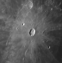 |
Mountains
 | Unlike the picture scanned from my 1963 "How and Why Wonder Book of the Moon", lunar mountains have relatively gentle slopes. They are extremely old, most being formed billions of years ago by mechanisms very different to those on Earth. Portions of the outer rim of the massive Mare Imbrium impact basin form the most significant visible mountain ranges including the Alps N|H2+3, the Apennines N|H5 with peaks rising almost 5 km above Mare Imbrium, and the Caucasus N|I4+5 with peaks approaching 6 km in height. Lesser ranges are associated with other impact basins. Isolated mountains Mons Pico C|G3, Mons Piton C|H3, Montes Teneriffe C|G3 and Montes Spitzbergen C|G4 were part of a now obliterated Imbrium basin inner ring. |
The central mountains within larger craters were formed by the rebound from the crater-forming impact. Both single and multiple peaks occur and they are not always at the centre of the crater. They can rise to significant heights above the surrounding crater floor. Examples include: Aristillus 0.9 km N|H4, Arzachel 1.5 km C|H10, Copernicus 1.2 km W|E7, Moretus 2.1 km S|H15, Petavius 1.7 km SE|N11, Piccolomini 2.0 km SE|K12, Pythagoras 1.5 km NW|E1, Theophilus 1.4 km E|K9, and Tycho 1.6 km S|G13. There are no mountains resulting from plate techtonics. The long extinct lunar volcanoes are shallow domes rather than towering mountains.
Volcanic Domes
Volcanic domes are amongst my favourite lunar features. Most are located on Oceanus Procellarum. With a diameter of 70 km, the largest is Mons Rumker NW|C3 which is actually a cluster of domes. The domes that lie between Copernicus and Kepler, the Hortensius domes W|E7 and Milichus domes W|D6, are more typical, with diameters of ~10 km, heights of 200 - 400 m and ~1 km caldera pits. Due to their gentle slopes, they are only visible at local sunrise and sunset, and quickly vanish. They represent a nice imaging challenge. Dozens of small domes cluster East of crater Marius in the largest lunar dome field, the Marius Hills W|B6. The impressive 20 km dome Mons Gruithuisen Gamma NW|D4 with its 1 km pit sits at the Northern end of Oceanus Procellarum. A number of small domes are associated with Vallis Schroteri NW|D5, itself a dramatic volcanic feature. Several domes are located on other maria. Mare Tranquillitatis harbours domes associated with rilles and faults near crater Cauchy E|L7, and Birt rille originates from a shallow dome in Mare Nubium S|G11. |  |
Faults
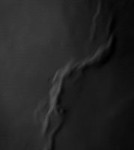
 | Lunar faults give rise to several types of lunar features: Wrinkle Ridges that occur on basaltic plains, a type of lunar valley or rille called Graben, and isolated faults. Rupes Recta (left) on Mare Nubium is an example of a "normal" isolated fault. It is 110 km in length and has a width of 2.5 km and maximum height of ~300 m - it is not a steep slope as suggested by its image. Other examples include Rupes Cauchy and Rupes Altai. Isolated faults are relatively rare. Lunar faults did not arise due to plate tectonics as in the case of many terrestrial faults. Rather they resulted from stresses in the lunar crust often associated with the cooling, shrinkage and subsidance of basaltic impact basins. |
Wrinkle Ridges
 | Wrinkle ridges are a common feature on basaltic mare deposits, such is Mare Imbrium and Mare Tranquilitatis, and on a few basalt flooded craters such as Wargentin. They formed as the freshly filled basalt basins subsided under their own weight. Compression buckled the surface, resulting in long raised folds and ridges that often extend for long distances. Wrinkle ridges are thrust faults. Due to their low profile - they are usually only 100-200 m in height, they can only be seen at local lunar sunrise and sunset. However the basaltic plain can be at quite different elevations on either side of the ridge as a consequence of the buckling process. Sometimes Wrinkle ridges follow the outline of ancient craters buried under basaltic plains, for example Lamont. |
Valleys and Rilles
Superficial resemblance is the only thing the ancient lunar valleys have in common with terrestial valleys. A handful of larger depressions are called valleys ("vallis"), whilst the more plentiful smaller examples are called rilles or rimae. There are several different types. Sinuous rilles resulted from lava flows and/or collapsed lava tubes. The largest sinuous rille is Vallis Schroteri NW|C5 (right), which is 160 km in length, up to 1 km in depth and 10 km across at its widest point. By any measure it is a large valley. For comparison, the Grand Canyon is 446 km length, up to 29 km across and up to 1.8 km in depth. Vallis Schroteri's flat floor hosts a narrow sinuous rille that looks like a river - I've not been able to see this directly. Other sinuous rilles include Rima Birt and Rima Hadley | 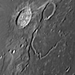 |
 | Straight rilles are graben, flat valleys formed when the crust between two adjacent faults subsided (right). Graben often occur at the edges of marie, where they have resulted from subsidance of the basalt causing faults to open up in long tracks. They can also occur in older cratered terrain. The prominent 180 km Vallis Alpes N|H2 is probably a flooded graben. A further example is Rimae Hippalus SW|E11, a group of concentric graben that follow the edge of Mare Humorium. |
Vallis Alpes (Alpine Valley) (right) mentioned above is an example shaped by several processes. The large structure was formed between two parallel faults when the crust was pulled apart. The flat floor and narrow sinuous rille running down its length was formed by subsequent lava flooding from Mare Imbrium and Mare Frigoris. The sinuous rille is good observing challenge. | 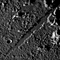 |